West of Ifield: Archaeological excavations
By Ian Mulcahy
Created 23 February 2026
A summary of the discoveries made during
archaeological investigations undertaken in and around the fields of Ifield
Court Farm between 2017 & 2021.
|
Between 2017 and 2021 several archaeological evaluations took place in the fields of Ifield Court Farm, to the west of Ifield Brook. In 2017, on the land where 'The Maples estate' opposite Ifield Golf Course was to be built, an initial round of trial trenching was undertaken followed by a 'Strip, Map & Sample Excavation' on an area of interest, and in 2019 an excavation was undertaken 175 metres to the north of The Maples in advance of Thames Water laying a new sewer pipe. In 2021 trial trenching was carried out across the fields of Ifield Court Farm to inform the now submitted planning application for the proposed West of Ifield development. The positioning of the trial trenches was informed by geophysical surveys which were carried out across the site in 2009 & 2019. These geophysical surveys also covered the accessible areas of Ifield Brook Meadows, to the east of Ifield Brook, though no trial trenching has taken place there.
The cumulative discoveries demonstrate that Ifield has been a continuous settlement for at least 2,200 years. Confirmed finds include a Middle Iron Age roundhouse, two Romano-British enclosures, two Romano-British cremation deposits, Roman era and Medieval iron production waste, a Neolithic (4,000 to 2,400 BC) flint blade, a Late Upper Palaeolithic or Mesolithic (14,000 to 4,000 BC) flint blade, a large amount of pottery dating from the Iron Age & Roman era and a Roman coin. Also discovered, and pending further investigation, was another possible roundhouse of Iron Age or Romano-British date, a possible Roman era track and an Iron Age or Romano-British enclosure.
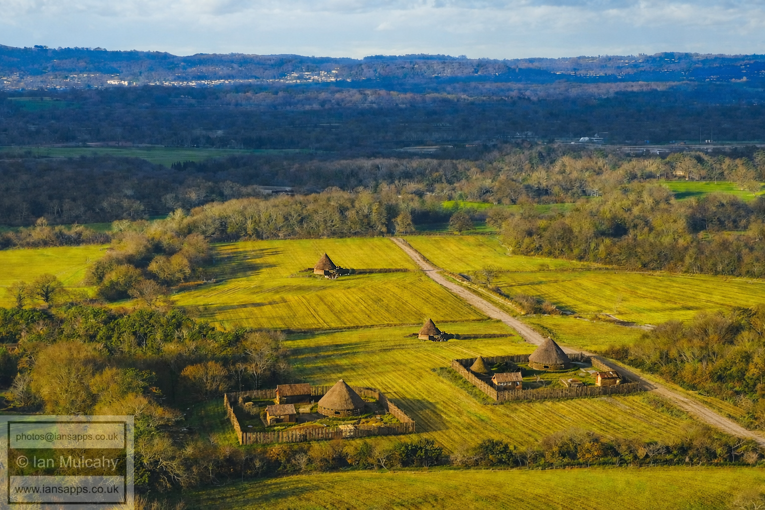
A visualisation (not to exact scale or position) of how the fields west of Ifield Brook may have appeared 2,000 years ago. This is a genuine aerial image of the area which has been amended using AI based on the archaeological evidence discussed below.
The proven existence of Iron Age and Roman era settlement here demonstrates that what the Saxons saw when they named Ifield (Ifelt, Yfeld), which means the clearing or settlement in the yew trees, was indeed a settlement.
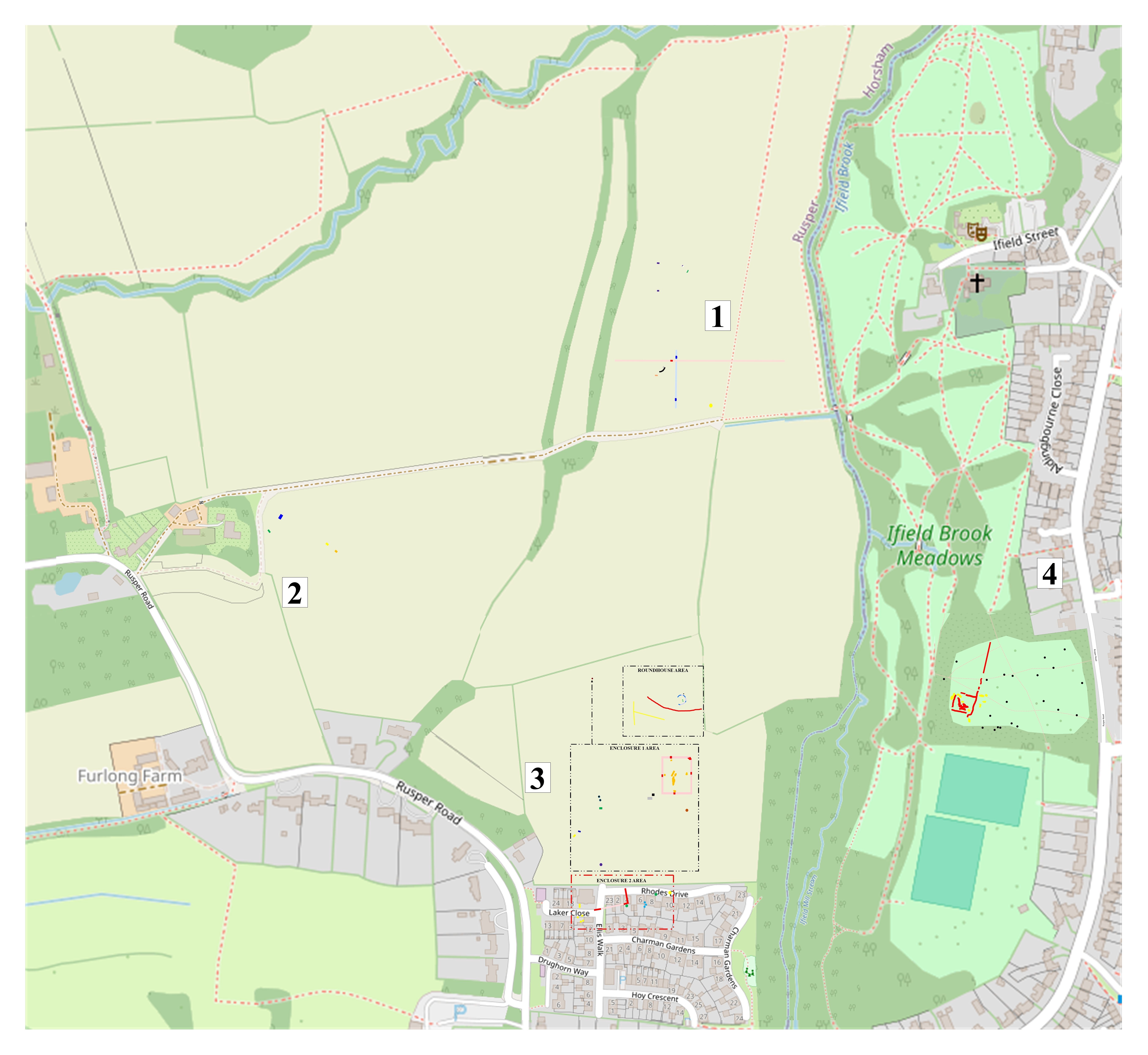
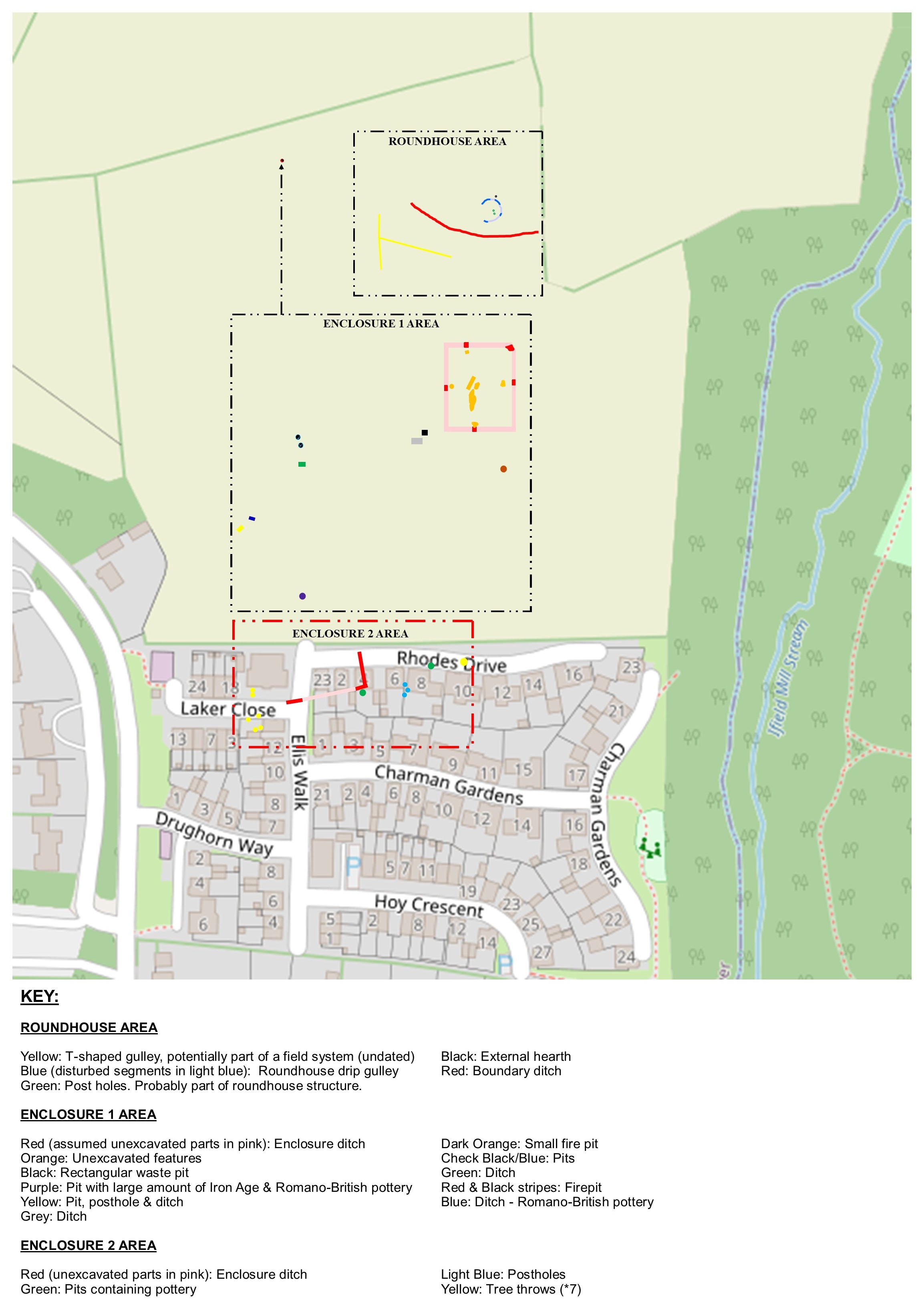
I have split the investigations up into four geographical segments for discussion and each segment contains a more detailed map showing where each find and feature is sited. All of the features and finds are colour coded and are marked exactly where they were found.
Full map of features to give a wider context of locations
Click the links below to navigate to each segment or simply scroll down. All maps are clickable for larger versions
CONTENTS
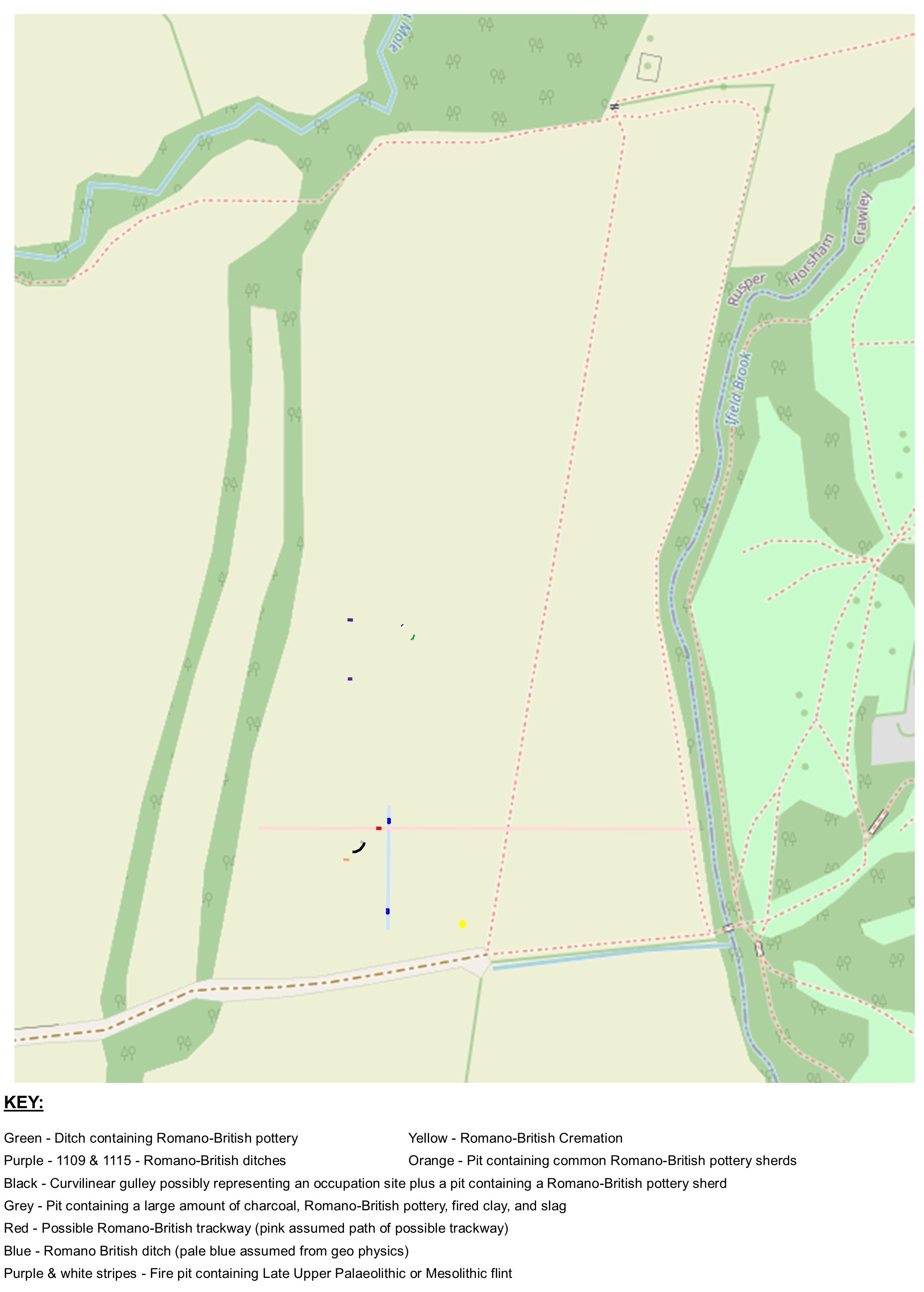
Area 1 is in the field to the west of Ifield Brook, to the north of the track to Lower Barn and, within this large field, to the west of the track to Druids and Ifield Court. A total of 29 archaeological features, comprising pits, ditches, postholes and cremation related deposits, were discovered in 9 of the 17 trenches dug.
The black curve represents the position of a curvilinear gulley which marks the site of a possible roundhouse. A single sherd of Samian pottery was recovered from this gulley, but this could be residual from a later pit, represented by a grey dot at the northern tip of the gully, which contained sherds of common Romano-British pottery. That this later pit cuts into the gully and contains Roman era artefacts means that if the gully is that of a roundhouse then the roundhouse could possibly be a further example from the Iron Age.
To the north of the gully, marked in red, was a shallow feature, 8cm deep, 134cm wide and as long as the trench was wide. This 'ditch' was filled with highly compacted material, including a relatively large quantity of Romano-British pottery and fired clay. The compacted nature of the fill suggests that this feature may have been some form of trackway rather than a ditch, and I have marked the possible path of this trackway across the field in pink.
To the south east of the site and represented on the map by a yellow dot, archaeologists discovered two deposits of cremation remains, including fragments of lower limb bone up to 3.5cm in length, a few fragments of cranium, pyre debris and a relatively large number of Romano-British pottery sherds in one of the deposits, which may have been part of a vessel which originally housed the remains. It is possible that both deposits contain the remains of a single person. The large amount of pyre debris suggests that cremation took, or was taking, place in the immediate vicinity and it could be linked with the possible settlement mentioned above.
Splitting the possible settlement and cremation sites and intersecting the possible track is a Romano British ditch, marked in dark blue (excavated) and light blue (assumed) on the map, this being one of four ditch features within Area 1 which were found to contain Romano-British Pottery. The other ditches are represented by the two purple and single green markers in the little cluster of features to the north.
The fourth feature, to the north and represented by a white and purple striped mark just above the green marked ditch, is a fire pit which was found to contain a Late Upper Palaeolithic or Mesolithic (14,000 to 4,000 BC) flint blade. A further pit, represented by the orange mark below the possible roundhouse gulley, was found to contain common Romano-British pottery sherds.
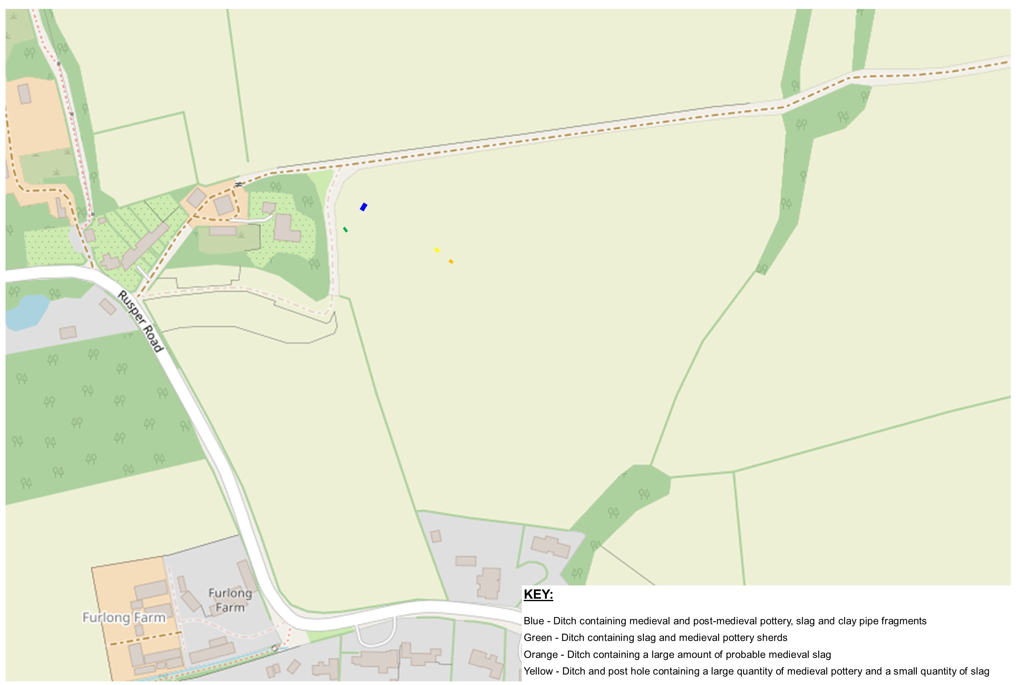
Area 2 is the field immediately to the east of Lower Barn and contained a total of 35 archaeological features comprising pits, ditches and postholes, in 11 of the 17 excavated trenches. Older finds were concentrated in the north-west quarter of the study area. It can probably also be said that this is the dullest area in terms of the archaeology, the oldest finds being from the medieval period (410 - 1485, though these finds are likely to be from the later end of that period). A lack of earlier finds could be an indication that this area was previously wooded, possibly by the yew trees around the clearing in which the settlement named by the Saxons lay.
A (blue) ditch containing medieval and post-medieval pottery, slag and clay pipe fragments was found in this area along with a further (green) ditch containing slag and medieval pottery sherds, another (orange) ditch containing a large amount of probable medieval slag and a final (yellow) ditch and post hole containing a large quantity of medieval pottery and a small quantity of slag. The slag demonstrates iron working in the immediate vicinity.
On the other hand, Area 3, which covers The Maples and the field immediately to the north, is by far the most exciting area. Covering The Maples estate and the field immediately to the north (a single field within the last 20 years - it was split in two by a hedgerow in c.2010), so much archaeology was found in Area 3 that I have split it into three sub areas, the names of which hint at what was found in each:
The Roundhouse Area, unsurprisingly, contains a Middle Iron Age roundhouse. Located to the north of the area, the remains of a truncated circular drip gulley, a standard part of a pre-historic roundhouse structure, 9 metres in diameter were discovered in 2019 prior to Thames Water laying a new sewer pipe across the site. This is marked in dark blue on the map with the light blue representing a visualisation of sections which have been destroyed by ploughing and natural erosion. Within the fill of the north eastern segment of the gully, 42 sherds of Middle Iron Age pottery were discovered and the two green dots within the circle represent post holes which probably contained structural posts related to the roundhouse. Charcoal discovered in one part of the gully returned a radiocarbon date of 309-208 BC and this broadly matches the typical dates of the pottery discovered. Roman era activity is also indicated by a single sherd of pottery found in one of the postholes, but this could be 'intrusive' and not linked to the roundhouse.
Immediately to the north of the roundhouse is a black dot representing an area of heat affected natural geology and indicating a possible external hearth, though it remains undated. It would be highly coincidental if this proves to not be related to the roundhouse. The red curvilinear feature represents a(n undated) boundary ditch of some kind which may be just the remains of an old field system, but the way it encloses the roundhouse site raises the possibility that it was an enclosure ditch and, if this is the case, the size of the ditch suggests that the enclosure contained more than a single roundhouse, though no evidence has been found for further dwellings in this area and no dateable material was recovered from the ditch. The yellow T-shape marking shows the position of two perpendicular gullies which are probably the remains of an old field system, not necessarily linked to the roundhouse.
Enclosure 1 Area is in the central and southern parts of what remains of the field and was trial trenched in 2021 as part of the preparation of the planning application for the prosed West of Ifield development. The positioning of some of the trenches was dictated by the results of the 2009 and 2019 geophysical surveys on the site, which returned some interesting anomalies in the north-eastern section of the Enclosure 1 Area.
As expected, the trial trenching confirmed the existence of a Romano-British enclosure (marked in red, with the unexcavated parts marked in in pink) measuring 40m by 30m. The finds in the excavated parts of the enclosure ditches provided the date confirmation, and these included Romano-British pottery, fragments of quern stone, slag, a single Roman coin of the 3rd or 4th century, animal bone and 5.7kg of CBM (ceramic building material), comprising of flat tiles, a box flue tile and small amounts of curved and flanged roof tiles. This is indicative of a building of greater status than a roundhouse, but don't get too excited - this is not a Roman villa. The County archaeologist called a halt to excavations on the enclosure to enable a full strip, map and sample excavation to be undertaken should planning permission be granted. The orange markings within the enclosure denote archaeological features that were not excavated as a result of this instruction.
The black square to the west of the south-west corner of the enclosure marks a pit which contained a large amount of burnt material and a small quantity of Romano-British pottery, slag and burnt bone whilst the grey marking just below indicates a ditch which contained Romano-British pottery and tile. The dark orange dot to the south denotes a fire pit - might this have been related to iron smelting?
To the west of the ditch, marked by two black and blue checked circles, are two small pits which both contained a small quantity of Romano-British pottery, slag and CBM and the green marking immediately to the south of these pits represents a ditch which contained a large amount of Romano-British pottery and CBM along with a couple of fragments of Iron Age pottery.
In the far west of the marked Enclosure 1 Area is a ditch, marked in blue, which produced a small amount of Romano-British pottery and the yellow marking indicates a pit, Posthole & ditch containing CBM and pottery sherds. The purple dot at the far south of the Enclosure 1 Area marks a pit which contained a large amount of Iron Age & Romano-British pottery and to the north of the Enclosure 1 Area and west of the Roundhouse area, linked by an arrow, is a red & black striped dot denoting the position of a firepit, which produced no dateable artefacts.
Enclosure 2 Area is in the northern side of The Maples development, straddling the boundary of this estate, which was produced some finds of interest during the initial trial trenching in 2017 and, as a result, was subject to a full strip, map and sample excavation later on that year, though an underground utility meant that the whole area couldn't be investigated properly. The red line denotes the enclosure, which measured 37.5m long (east to west) and 17m wide (north to south) before continuing beyond the limit of excavation and has been dated to the Romano-British period based on the large amount of locally produced* and imported pottery discovered within the ditch, which included a group of semi-complete vessels from the early to mid-2nd century and some late 1st century sherds. The pink section is the assumed continuation of the ditches in the area that couldn't be excavated. The total weight of pottery recovered from the excavated enclosure ditch was almost 9kg, made up of over 600 sherds. Also found in the ditch, during the first excavation, was a rectangular slab of sandstone, 46cm square in area, which had been used as a whetstone or polishing stone and was dated to the Roman period by association.
Further Romano-British pottery was discovered in the two pits marked by green dots, one of which contained a very large and thick-walled piece of pottery. The rim of the pottery has little curvature indicating it would have had a very large diameter if it were a storage vessel, and the archaeologists have surmised that this artefact may in fact be part of an oven opening/door. The semi-circular cluster of three blue dots to the east of the enclosure represent 3 post holes which, it is said, could have formed some kind of windbreak. This doesn't feel like the correct interpretation as the configuration would protect against a south-easterly, whereas our wind comes predominately from the south-west. Also discovered during the original trial trenching were three struck flints, one being a blade with a worn, serrated edge with the other edge having been worked to allow the blade to be held comfortably in the hand during use. This been dated to the Neolithic period (4,000-2,400BC). The other two pieces of flint were waste flakes.
The series of 7 yellow dots indicate undated tree throws, which I've included for interest - perhaps they were some of the Ifield yews? The Tithe map of 1839 records that the field was named 'Twelve Trees'.
The previously mentioned pit marked by the purple dot at the far south of the Enclosure 1 Area, which contained a large amount of Iron Age & Romano-British pottery, may well have been within or just outside of the enclosure in Enclosure 2 Area and be related to that feature rather than enclosure 1. It's also worth considering that a deliberate dump of such a large amount of Iron Age pottery (over 250 sherds from at least 12 individual vessels with a combined weight of more than 1.8kg) from the 3rd to 1st century BC being here, over 200 metres away from the location of the roundhouse, could hint at the possibility that the Middle Iron Age site was larger than just a single roundhouse, with the evidence for this being sadly lost to the plough, or the second enclosure, over the intervening centuries. As a footnote to this, several undated pieces of fired clay were also recovered from the purple pit, one of which was found to have a circular impression resembling a wattle impression. Wattle was, of course, used to form the infill of timber structures with a daub covering which was often made from clay. Is this a remnant of an Iron Age or Roman era home which burnt down or was taken apart and used as fuel when it had reached the end of its useful life?
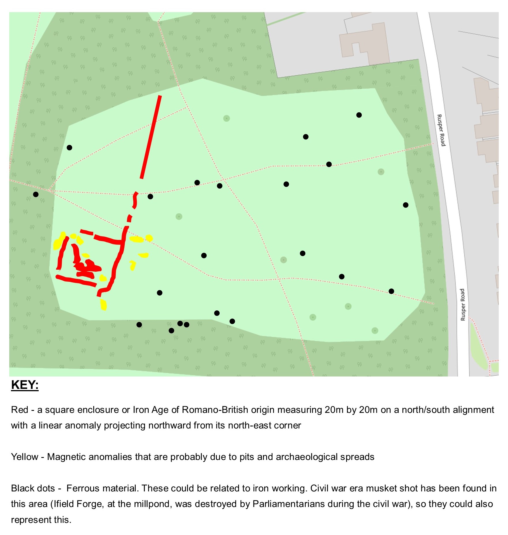
Area 4 is in the field to the immediate north of Rusper Road Playing Fields in Ifield Brook Meadows. This area has not been subject to any trial trenching as no development is proposed here, but it was subject to a geophysics survey anyway and the results showed that the evidence of an almost certain Iron Age or Romano-British enclosure is hidden just below the surface close, and to the east of, the original path of Ifield Brook (see The Non Designated Heritage Assets West of Ifield for more details). The yellow markings in and around the edge of the enclosure indicate magnetic anomalies which probably represent pits.
A linear anomaly of some kind projects northwards from the north-east corner of the enclosure (marked in red); might this be a track? It leads in the direction of St Margaret's Church and it is known that many medieval churches (St Margaret's was built in 1200, and was probably pre-dated by an earlier timber church on the site) were built on sites of religious activity that preceded Christianity in order to send a message that the old pagan religions were finished. That said, once the surveyor had passed through the cluster of trees to the north and was able to pass his equipment across the ground once again, the possible track was not recorded, so it appears unlikely that it led to the site of the church.
The black dots indicate ferrous material markers. This material could be anything of course, from lost horse shoes to dropped nails, but an undated bloomery (used for iron smelting) has previously been discovered in this field, so they could be linked to iron working. If you're thinking to yourself that's an awful lot of bloomeries though then, for context, the investigation into the Iron Age and Romano-British iron working site at Broadfield produced no fewer than 53 bloomeries in the areas excavated. It has also been reported that Civil War era musket shot has been discovered in this field, dropped or fired during the destruction of Ifield Forge by William Waller's Parliamentarian troops in 1643 perhaps, so this should also be considered as an explanation for the magnetic markers.
The results of these surveys and investigations prove beyond any doubt that Ifield has been continuously settled for in excess of 2,200 years. When considered alongside previous discoveries in and around Crawley; the Late Bronze Age (1100-800BC) settlement within the modern boundaries of Gatwick Airport and nearby sword deposit in the Polesfleet Stream, the Bronze Age burial mounds at Pease Pottage, the Iron Age settlement at Goffs Hill, the Romano-British Settlement on Hogs Hill where Hilltop Primary School now stands, and the huge Middle to Late Iron Age and Romano-British iron working site at Broadfield, we can see that the area has an evidenced history of human settlement that stretches back around 3,000 years; Crawley is far from being just a post war new town. We'll never know what relationship the people of the Ifield settlements had with those occupying the Southgate & Broadfield sites. They may have been friends or trading partners, they may have just coexisted with mutual indifference or they may have been sworn enemies, but it seems inconceivable that two large communities a mile and a half apart would not have been aware of each others existence.
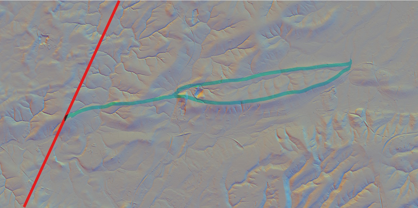
*Much of the pottery discovered across the site has been identified as being produced at Alice Holt near Farnham and at Hardham, near Pulborough. This shows that the population in Ifield had established trading partners and, to facilitate these partnerships, there would have been established trading routes too. It seems an obvious conclusion that the products from Alice Holt would have travelled along the Pilgrims Way to Stane Street at Rowhook via Ewhurst and that the products from Hardham would have travelled north along Stane Street, but how did they get from Stane Street to Ifield? There is a clear ridge from Rowhook to Warnham where the ridge then splits into two, creating two ridge links between Warnham with Ifield, the lower being across the top of Hurst Hill and then along the modern Wimlands Lane and Kilnwood Lane, and the upper terminating at the eastern end the ridge across the middle of Ifield Golf Course. Are there ancient trackways waiting to be discovered here?
A 3D Lidar scan showing Stane Street (marked in red) and the possible ridgeway route from Rowhook to Ifield (highlighted in blue)
Note not related to the archaeological discoveries, but contained within the reports, is the observation that what are geologically known as 'superficial deposits' (essentially material that was deposited on top of the sedimentary bedrock geology by glaciers or river flows, in this case river terrace deposits of sand & gravel) in the east of The Maples site are of the Late Glacial period, that is roughly 15,000 to 11,700 years ago. The British Geological Survey mapping shows that these river terrace deposits are to be found on both sides of Ifield Brook demonstrating that (the original) brook chose its natural path through the landscape at least 11,700 years ago.
Text & photographs © Ian Mulcahy. Contact photos@iansapps.co.uk or visit my 'Use of my photographs' page for licensing queries (ground level photographs only). |