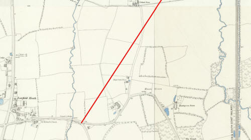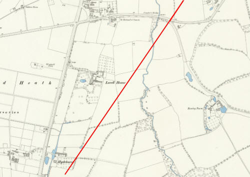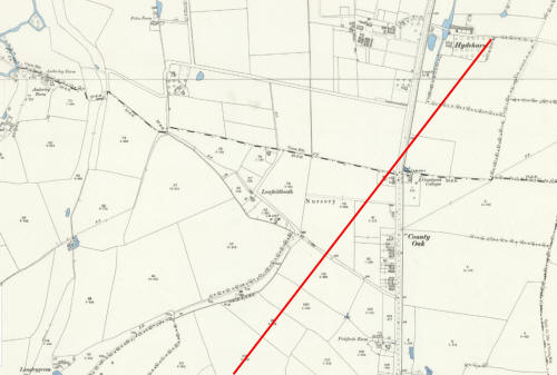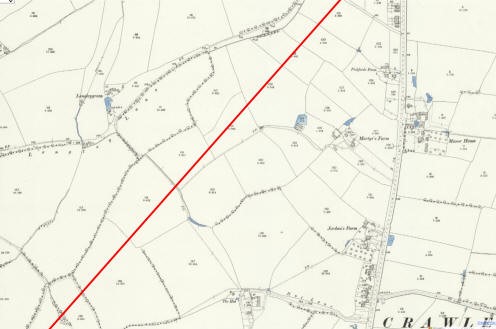
(Buildings, from left to right: Ewhurst Place, Old Martyrs, Jordans Farm,
Gatwick Manor)
The original plans for the Arun Valley railway line to Horsham
Drawn up in 1838
By Ian Mulcahy
August 2022
|
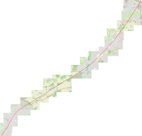
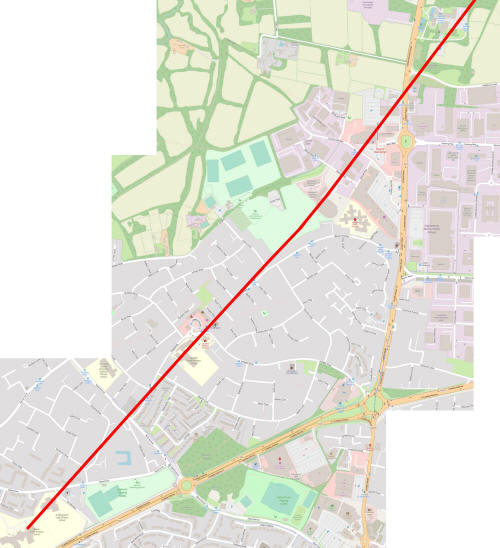
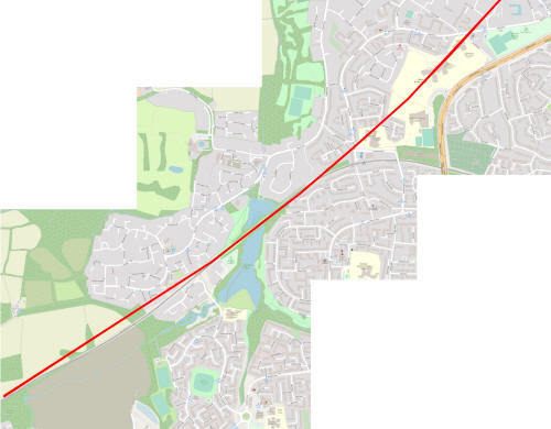
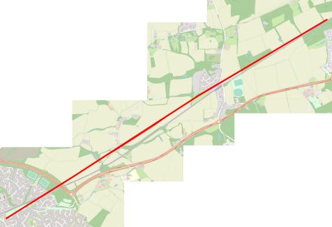
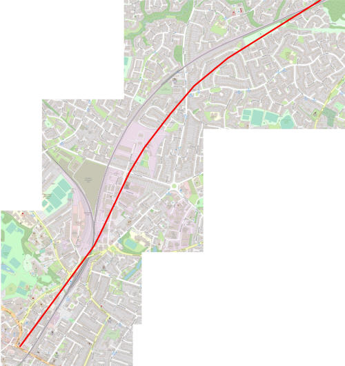
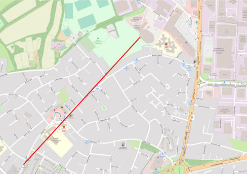
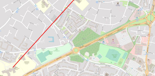
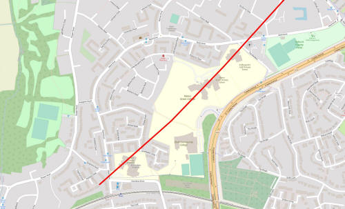
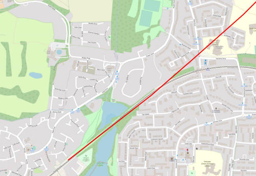
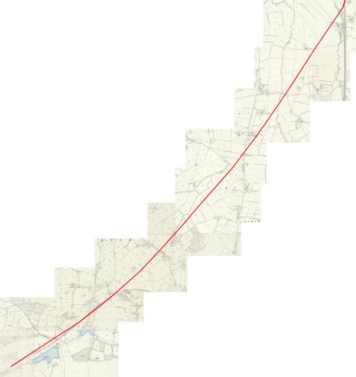
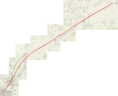
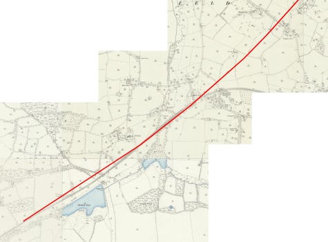
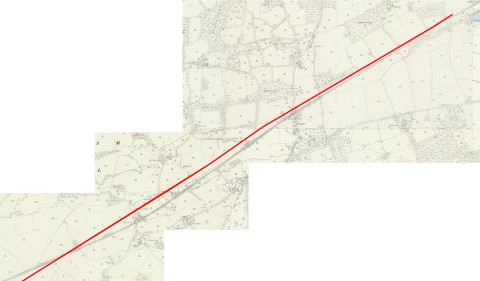
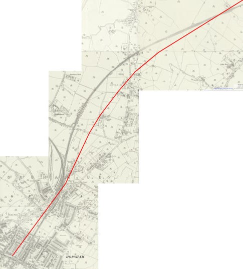
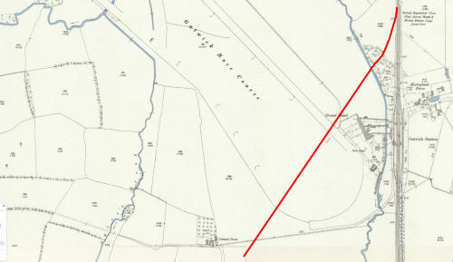
I was recently visited the West Sussex Records Office in Chichester to view and photograph the plans for the originally proposed railway line which would link Horsham with the Brighton Mainline (catalogue number QDP/W71). The plans show a vastly different route to that which was eventually constructed and I think Crawley would be a much different place in 2022 if it were the original plans that were followed. We will look at those plans in detail shortly, but firstly lets look at the background of what was delivered by the London, Brighton & South Coast Railway (LB&SCR) over 170 years ago. We are all familiar with the Arun Valley line. It opened on 14 February 1848 and branches from the Brighton mainline immediately south of Three Bridges Station, taking travellers to places such as Arundel, Littlehampton, Bognor, Portsmouth & Southampton, via Horsham. It was originally a single track line stopping at Crawley and Faygate, each with two platforms so that trains travelling in opposite directions could pass each other, and terminated at Horsham. The line was doubled for the entire route during 1862 when the line was extended to Arundel Junction, creating a through route to Portsmouth. On 1 June 1907 three 'halts' were introduced, Lyons Crossing Halt, Roffey Crossing Halt & Rusper Road Halt. A halt was effectively an unmanned station which functioned as a request stop; the train would slow as it approached the platforms and any passengers waiting to embark would signal their intent to join the train by waving their arm, which the driver would acknowledge with a toot or a whistle. Those already on the train wishing to alight would pull a cord which rang a bell to alert the driver. To most people the names of the three new halts will mean very little, but you'll know two of them at least. Lyons was renamed 'Ifield Halt' within a year and became simply 'Ifield' in 1930. Ifield station was closed on 1 January 1917 during World War 1, but reopened again on 3 May 1920. Roffey Crossing Halt was renamed 'Roffey Road Halt' less than two months after opening and was also closed from 1917 to 1920. It closed for good in 1937, but there is currently much talk about it being rebuilt to serve the rapidly expanding North Horsham development. The remains of some of the platform supports on the 'up' side can still be seen just down the line from the level crossing in Wimlands Road off the A264 as you leave Horsham. Rusper Road was renamed 'Littlehaven Crossing Halt' a month after opening and lost the crossing to become 'Littlehaven Halt' a further 6 months later. 'Halt' wasn't dropped from the name at Littlehaven until 5 May 1969. The route we know today was selected as the LB&SCR saw Crawley as a ready made source of customers, though at the time Crawley was a small market town of around 750 people centred around a High Street which was developed from the southern corner of Three Bridges Road (Now Haslett Avenue West) to 'The Tree', home to Crawley Museum. West Green was a smattering of houses along Smalls Lane and around the green itself while Southgate was just a handful of isolated farms. This seems to be a small number of potential customers, but it is a much greater number than would have been close to the route which was first proposed. It is also worth noting is that Three Bridges Station was originally called 'East Crawley', so the town was clearly on the minds of the LB&SCR well in advance of the route of the Horsham branch line being decided upon. Unfortunately, and frustratingly, I do not have permission to share the images of the original plans, but what I am able to do is to mark the proposed route on a modern open data source map which ultimately gives it more context to a contemporary reader anyway. To create these maps I have broken the original plans into fifteen sections and, using late nineteenth and early twentieth century Ordnance Survey maps (I will refer to these as the 'old OS maps') which show broadly the same field boundaries as the railway plans, I have plotted out the route. I believe I have been accurate to within no more than five yards. The National Library of Scotland Maps have a fader facility within the geo-referenced map section whereby a user can create a hybrid of two maps. I have used this, with Bing Aerial maps, to match up with the original plotting of the route on the full old OS maps, and then overlaid a full aerial map. Microsoft do not allow use of these maps on an open license, so this stage is not displayed here. I have then used the modern road layout seen on the full aerial map to overlay the Open data Source maps. I have then created five larger maps, each of three joined sections, and from those five created two further maps - sections one to nine and sections ten to fifteen. Finally I have joined those two together to create one map of the entire route. All of the Open maps and old OS maps are reproduced below. The plans were dated 1 March 1838 and were drawn up by John Urpeth Rastrick and Joseph Gibbs, who signed the plans as 'Engineers'. Rastrick was also responsible for the construction of the London to Brighton mainline (opened 1839) during 1838 whilst Gibbs was involved in its design. The plans show show that the branch line was to leave the Brighton mainline north of Gatwick Airport station, close to where it passes under the approach to the M23, and ended at Horsham Station, which was proposed to be where Barttelot Road joins East Street, next to what was then the town's prison. To get there it would have passed Lowfield Heath, County Oak Retail Park, The Old Martyrs, Langley Green school, Ewhurst Place, straight through St Margaret's school and and The Mill Primary before roughly aligning itself with the eventual build at Ifield Millpond, though small deviations, both to the north and to the south, are seen on the remainder of the route. The maps below start by showing the complete route and then break down into ever more detailed images. The pictures are fairly high resolution and are best viewed when clicked (this page shows low resolution thumbnails). The route is discussed in greater detail below the individual maps.
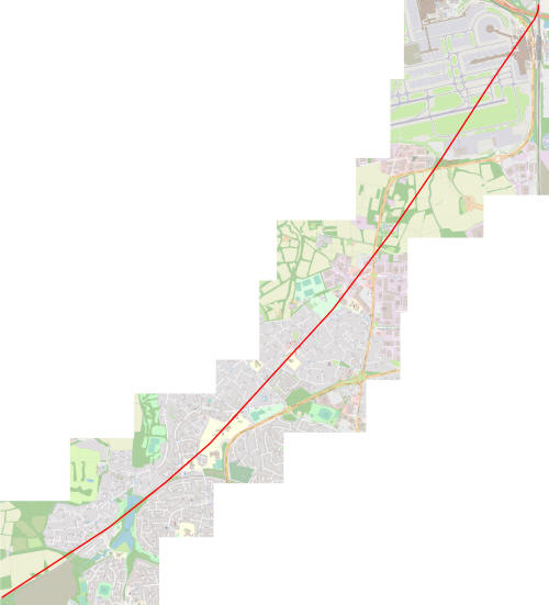
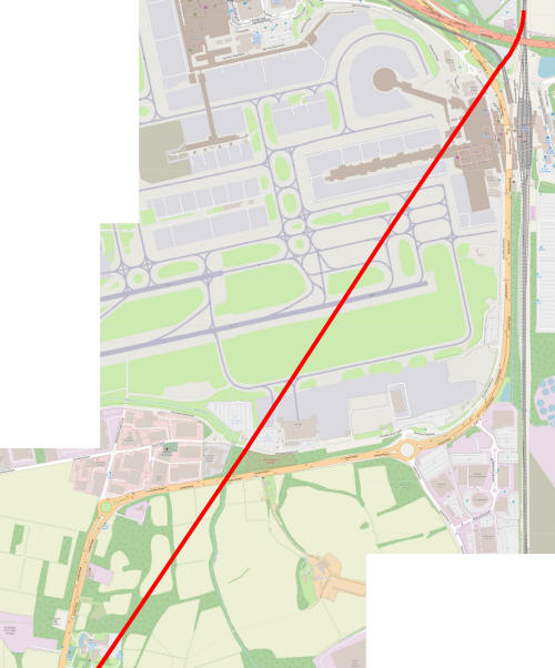
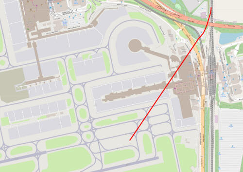
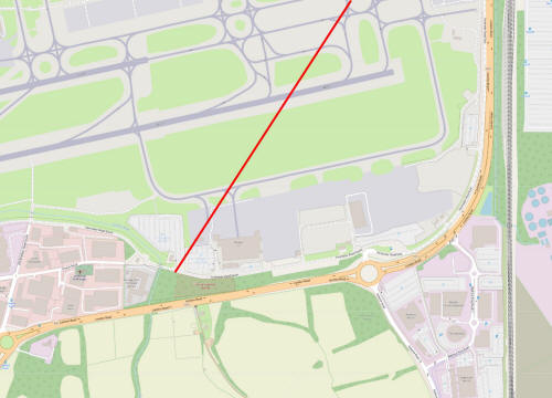
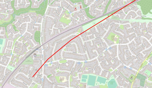
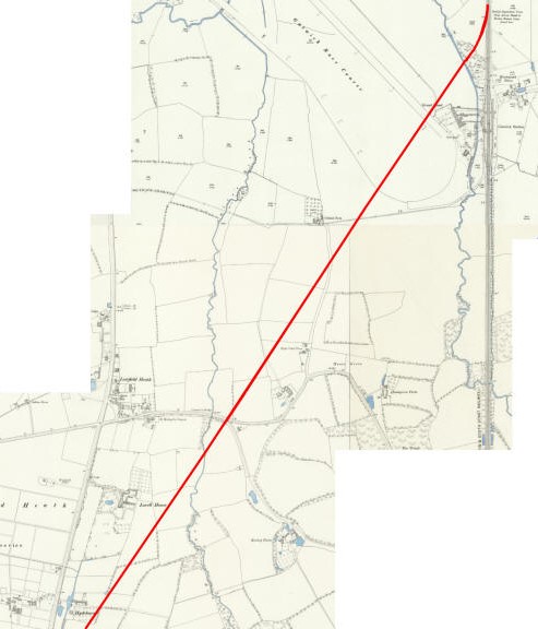
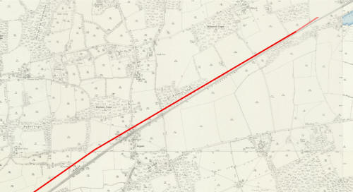
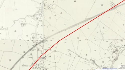
Sections 1 - 3 (Gatwick to Gatwick Manor) Modern Map. the branch line leaves the mainline at the modern day border between Crawley & Horley (and West Sussex & Surrey) and slices across the north west corner of the south terminal and through the eastern end of pier two. Having crossed the runway and perimeter Road south it leaves the boundaries of the airport next to the immigration centre, making it's way through the fields to the south of the A23 before cutting through the rear car park at Gatwick Manor. Old OS Map Before the airport was developed after WWII, the land here was a racecourse (it even hosted the Grand National three times during the First World War) which had opened in 1891 and closed in 1948. As can be seen on the old OS maps further down this page, the track would have passed close to the grandstand and then cut the track in two. There was no dual carriageway around the site at this time (the London Road cut straight across where the runway now is from Lowfield Heath crossroads to Povey Cross) and the only road to be crossed by the track was that which linked Charlwood with Tinsley Green via Lowfield Heath. Much of this road survives in the form of Church Road, the perimeter Road South, Gatwick Road and Radford Road. 1838 plan At the time the plans were drawn the road layout was pretty much unchanged from how it appears on the old OS maps, below. The branch line started in the Parish of Horley and crossed into Charlwood Parish almost immediately, the boundary line beingroughlyywhere the monorail is now. The land in these sections is virtually all noted as being arable, meadow or pasture, with the odd orchard thrown in for good measure. To the north of the Charlwood to Tinsley Green road most of the land was owned by either William John Sharp or John Robinson, though the odd field was owned by other parties, including 'where the monorail is now. The land in these sections is virtually all noted as being arable, meadow or pasture, with the odd orchard thrown in for good measure. To the north of the Charlwood to Tinsley Green road most of the land was owned by either William John Sharp or John Robinson, though the odd field was owned by other parties, including 'The Governors of Christ's Hospital', which was still based in Hertford and was some 60 years away from moving to it's present site in Horsham. To the south of the road was a common at Hunts Green which was a triangular area of common land, the boundaries of which can still be seen. The western boundary of the common is the bridleway that leads to Rowleys Farm from the A23 (and continued north of the A23 as a, now rerouted, public footpath which linked to Church Road). This formed a southerly point, some 150 metres along the bridleway, with what is now a row of trees which forms the eastern boundary. The northern boundary was Church Road. Other than the common, most of the land was owned by Charles Middleton, a descendant of the Middleton family of Horsham, two generations of whom served as MP for Horsham and who leased, and later owned, the Bewbush estate from the mid 16th century. The Middletons also built the first two corn mills at Ifield (in 1660 and 1683), repurposing the hammer pond on the site of Ifield Forge which was destroyed by the Parliamentarians in 1643 during the civil war. The current mill at Ifield was built by Thomas Durrant in 1817.
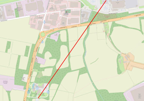
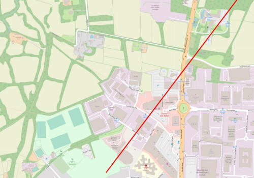
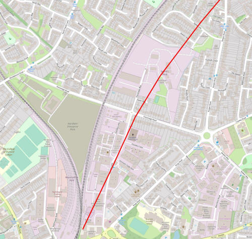
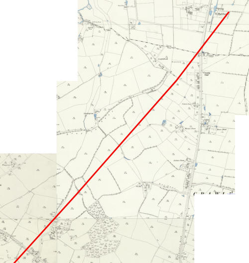
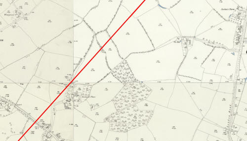
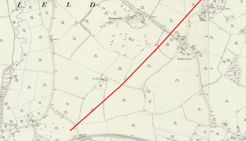
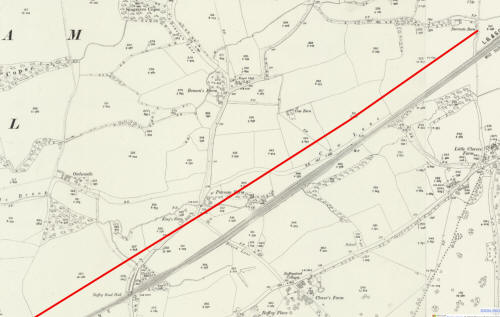
Sections 4 - 6 (Gatwick manor to St Margaret's School) Modern Map. Leaving Gatwick Manor, Hydenhurst Lane will need a level crossing in order for the Tesco.com drivers to leave the warehouse with our groceries and the track crosses the London Road shortly afterwards, passing behind Astral Towers and cutting the new Smyths/Aldi/M&S building in half. The industrial units behind Halfords would not be possible, and the recycling centre loses its western end (and not by way of fire for a change!). The track joins Martyrs Avenue at the end of Cherry Lane and follows it to the shops where it continues in a straight line through Langley Green Primary School and along Stagelands. Crossing Ifield Avenue the owners of Ewhurst Place get a train track in their garden, a train track which then demolishes another school, this time St Margarets. Old OS Map Most of this land was farmland on the old OS maps and having crossed the border from Surrey into West Sussex at County Oak the track passes Pickfords Farm, which is now under the car park of the Retail Park and was sited a little south of a bridleway leading to a couple of old cottages (which still exist amongst the industrial and trade units) and is now County Oak Way. Martyrs Farm (now at the end of Martyrs Avenue, but no longer a farm of course), Jordans Farm (the Toby Carvery in Vancouver Drive occupies the 17th century barn and the 16th century farmhouse adjoins the car park) and Ewhurst Place are also passed before it crosses Ifield Road between Ginhams Farm (next to the subway at the end of what is now The Mardens) and Deerswood, a large 14th century medieval house that was demolished and replaced with the modern architectural wonder that is Deerswood Court). 1838 plan Unsurprisingly, most of the land was farmland 60 years previous to the old OS maps too and, like on the old OS maps, the track crossed into West Sussex, and the parish of Ifield, at County Oak, but not before it had first crossed the 'Turnpike Road from London To Brighton' - what we know as the London Road or A23. The rail plans proposed that the road be raised by 20 feet (6.5m) to create a bridge over the railway. At Ifield Road (The Mardens), at the exact point where the entrance gates to St Margarets School are, it was proposed to raise the highway by 32 feet 'to be passed over the railway' or by 12 feet to be 'passed on the level of the railway'; an embankment was also planned here. Land ownership in this section is split between John Caffyn (a local family who later built Caffyns Mill on Station Hill in Three Bridges and owned a well known local car dealership), Lord (Robert) Rodney, Lord of Ifield Manor, and Captain (later Admiral) Matthew Buckle. Caffyns land was in the northern part of Langley Green around Martyrs and Jordans Farm and stretching to a little south of Cherry Lane. Buckle's land was from here to Hare Lane/Maiden Lane and the rest belonged to the Lord of the Manor and was leased to Arthur Mills of 'Hewards Farm' (a mishear of the Sussex dialect pronunciation of Ewhurst Farm).
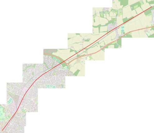
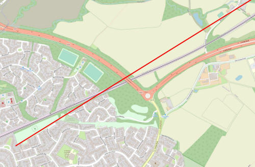
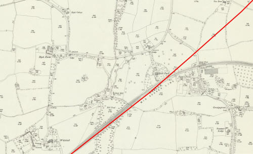
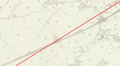
Sections 7 - 9 (St Margaret's School to Kilnwood Vale Modern Map. As the track continues southwestwards it's apparent disdain for modern education persists as it cuts through both Manor Green Primary School and College and then The Mill Primary school, emerging into Ifield Drive at the school's entrance not 100 yards to the north of Ifield Station. When it reaches Ifield Park it joins the current track, but crosses slightly to the south before the millpond causeway, re-aligning again before hitting dry land on the pond's opposite bank. At Hanbury Road it deviates northwards again and at the point where it crosses Mill Lane (the track which leads from the footcrossing linking Bewbush Water Gardens to Kilnwood Lane and a reference to Bewbush Mill, rather than Ifield Mill) it is around 75 metres to the north of the present track. The gap closes to perhaps 10 metres, but the proposed track will remain north of the actual track now until it reaches the outskirts of Horsham. Old OS Map The rural theme continues across what is now the Ifield school campus with no features of note until it reaches the main Crawley to Rusper Road, all of which can still be traced. The road was a left turn on the bend of Ifield Road into what is now Goffs Lane near to Snell Hatch cemetery. The road crossed the railway by way of a level crossing where the footbridge into Goffs Park can now be found and went up the hill to the footbridge at Gossops Green traffic lights. When you near the Gossops Green end of Overdene Drive you may notice a crossroads just before the roundabout - that is Gossops Green Lane and formed part of the road. Finally it descended Craigans to Ifield Station, over the level crossing and veered left down what is now Tangmere Road (note how the corner here wasn't developed and the houses cut the corner at 45 degrees to Ifield Drive and Tangmere Road) to Rusper Road. To the south is Lion's (or Lyon's) Farm - from where the station got its original name) and to the north Ifield Park, a 'gentleman's residence' built on undeveloped farmland in around 1860. The Mill and Millpond appear much as they do today, though the pond extends slightly further north-east on the Gossops Green side - an area that was backfilled to the tunnel under the railway when new Town Gossops Green was built. The track joining the mill with Lyons Farm (and so Crawley) is still there, though the steep climb up the railway embankment to use the crossing must have blunted it's usefulness somewhat. Once the railway was constructed, the track down to Rusper Road, from which the mill is accessed from modern day Hyde Drive and, on the other side of Hyde Drive was repurposed by Arthur Road, would have been the main route to town from the mill. After the millpond is crossed Whitehall Farm, demolished to make way for Ifield West, is to the north followed by Bewbush Pond, now under Kilnwood Vale, to the south. 1838 plan We stay in the Parish of Ifield and the rural landscape is pretty much unchanged until we reach the 'Ifield to Glossops (sic) Green Road', which is to be raised by 22 feet and 6 inches. It is not specified how this will facilitate the railway crossing it, but as the plans show embankment here it is fair to assume it would be by level crossing. On the stretch to the millpond we see Lyons Farm to the south, but the site of Ifield Park is arable land. When the railway was first built it crossed the millpond by way of a wooden viaduct (click here to see a wonderful painting of it by Denys Ovenden). The earth embankment that exists today came in 1861. To the north, again is Whitehall farm, strangely noted as 'Hales Farm' on the plan. The Tithe Map, surveyed a year later, names it as Whitehall, as does an early OS map from 1795 so this may have been a mishear like at Ewhurst (though the 1795 map refers to 'Hewards', just as this plan does). As we cross into the Parish of Lower Beeding, to the north of Bewbush Pond is the appropriately named Pondside Farm. In these plans the track runs straight through the northern most building of the farm, but in the 1844 plans (which were the ones enacted) the line passes inches to the south of the southernmost outbuilding. The farm was demolished to allow for the construction of the railway, but it was already showing as being unoccupied by 1839 (on the tithe map) which suggests that land and buildings were being acquired by the LB&SCR on the back of these plans. However, the 1844 plans show the farm as being occupied by Elizabeth Stepney, widow of Henry (see below). The land stays in the hands of Lord Rodney and under the control of Arthur Mills until the 'Ifield to Glossops (sic) Green Road' and the land from the road to the millpond, including *most* of Lyons Farm, is owned and occupied by William Hutchinson. The Millpond, Mill, Millhouse, spillway and a couple of meadows are owned by Thomas Durrant who, in 1817, built the mill which survives in a restored and working state. Strangely Durrant also owns the pond at Lyons Farm. The track from the mill to the Crawley to Rusper Road via Lyons Farm is shown as a Parish Road in the plans. Land to the west of the millpond is owned by Colonel James Clitherow of Brentford, a friend of William IV, who leased Whitehall Farm and the land surrounding it, to Thomas Barnes. The Clitherow family connection to Crawley came about when the Colonels Grandfather, also named James, married Phillipa Gale who inherited a third of her fathers estate on his death in 1750. Phillipa was the daughter of Leonard Gale who operated Tinsley Forge (which was located a little way behind the Greyhound Pub in what is now the Forge Wood Estate) and has a road in Three Bridges named after him; Gales Drive. The Colonel also owned Malthouse Farm in Southgate. Across the parish boundary in Lower Beeding all of the land is owned by Thomas Broadwood of Holmbush (formerly Bewbush) and most is leased to Henry Stepney. At this time the mill, built on the site of Bewbush Furnace to repurpose the Furnace Pond, was still operational. See 'The Hidden History of Bewbush' for more details on this area.
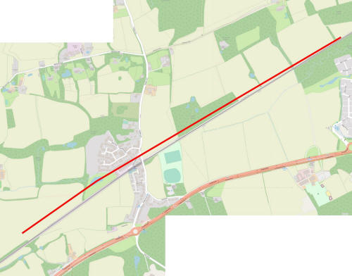
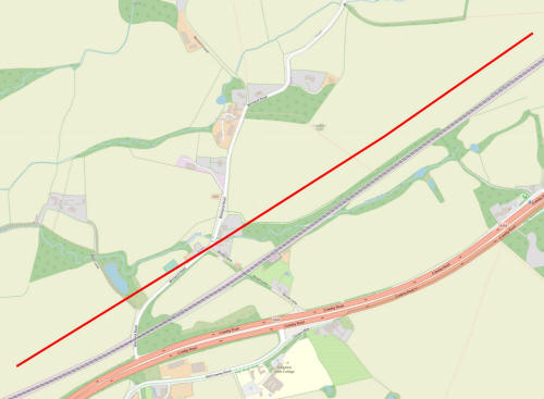
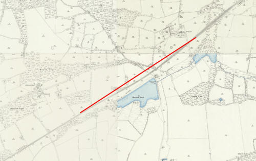
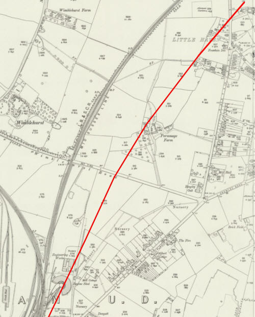
Sections 10-12 (Kilnwood Vale to Roffey) Modern Map. The proposed track remains to the north of the actual track as it passes through Faygate with the gap once again widening as it crosses Wimands Road at the junction with Brook Lane, some 100 metres away from the railway. As it crosses the A264 and passes close to the 'Theatre of Trees', home of Roffey Football Club, it crosses the track again. Old OS Map Running between the planned and constructed railways as it approaches Wimlands Road is Cow Lane. Once an important track linking Parsons Farm on Wimlands Lane with Little Clovers Farm and the Cherry Tree, Cow Lane is now just a bridleway across the middle of an arable field and through a small copse alongside the railway, with a crossing at the sharp right turn to Little Clovers. Parsons Farm, a 15th century open hall house with 16th century additions behind, would have been obliterated by our 1838 plans, but the farm house (now known as 'Brook House') and the neighbouring late 16th century barn survive. Kings Farm, a 17th century building a little way west, would also have been lost. 1838 plan East of Faygate Lane, which has a slight dog leg just south of where the track crosses which was straightened to accommodate the bridge across the line we see today, it passes through a 300 yard wide finger of the Parish of Rusper where the main landowner is noted as being George Knight. I have found a record of a George Coldham Knight as being a landowner in Rusper in the early 1800s, but he died in 1833 leaving property to his son Charles. Earlier plans I have seen for other transport infrastructure projects in this area name Charles Knight as the landowner, so I think it's likely that this ownership has been logged incorrectly and should name Charles Knight. West of Faygate Lane we move into Horsham Parish and the track obliterates Durrants Farm. Durrants Barn, a surviving outbuilding, can be seen on the old OS Map, but this too has now gone and it's footprint has been lost to the plough. Land between Faygate Lane and Wimlands Road is split between a few names including Knight, James Waller (the Cherry Tree, an adjacent cottage and a couple of surrounding fields), Edward Jenden, William Sharp, Roberta Lockwood (Parsons Farm), James Hammond (Kings Farm), Sarah Waller (Brook Cottage in Brook Lane) and The Duke of Norfolk. Having crossed Brook Lane and Wimlands Road the track is firmly in the territory of the Duke of Norfolk (who at the time was Bernard Howard, the 12th Duke), though there is the odd small parcel of land owned by individuals of a lower status particularly around the area that is modern day Earles Meadow, where Maria Ann Heaton owns a few fields.
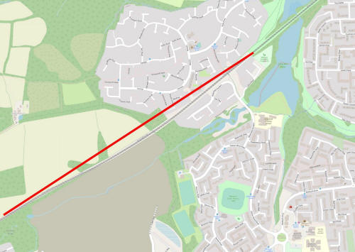
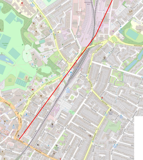
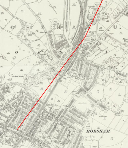
Sections 13-15 (Roffey to East Street, Horsham) Modern Map. Having crossed the actual track at Earles Meadow the proposed track shaves the northern flanks of Amberley Close and Rowlands Road before cutting Farhalls Crescent in half, emerging on Rusper Road right on the junction with Lambs Farm Road, some 200 metres south of the level crossing at Littlehaven Station. The track then slices through Parsonage Farm industrial estate, clips the corner of the Kingdom faith Church in Foundry Lane before joining North Street just town side of the railway bridge, grazing the roundabout outside of the train station and running almost parallel with the actual line until it reaches East Street at it's junction with Barttelot Road, where Horsham Station was to be built. Old OS Map The track passes mainly through farmland until it reaches Rusper Road at its junction with Lambs Farm Road which, at the time, was nothing more than a 100 metre long track leading to Lambs Farm, the 17th century extant farmhouse, and it's long since lost outbuildings. If this plan had been proceeded with, the farm house probably would have been lost too. Having crossed Rusper Road the driveway to Haven Cottages which, at the time of the plans, seems to have been known as the Windmill Public House. With the plans showing a cutting here, it is likely this building would also have been lost. The western end of Agate Lane, at the time a 100 yard lane rather than the lengthier affair we see today, was grazed as was Parsonage Farm. South of Wimblehurst Road, roughly where a nondescript brick mixed use building occupied by a company called 'ASL; Systems Integration, Repair & Overhaul' stands is a semi-circular engine shed which the track cuts straight through the middle of. South of the station my map shows Northchapel apparently being destroyed, but my line is wider than the the track and the plans show it bending slightly away from this grade 2* listed 16th century farmhouse, which still stands. 1838 plan As the track exits Spooners Wood; woodland which was where the Lemmington Way & Batholomew Way estate now stands, as well as an area south of the actual track, it crosses land owned mainly by Robert Henry Hurst of Horsham Park (MP for Horsham) including Lambs Farm which is leased by Hurst to William Jenkins. The Hurst family had been major landowners in the area since the mid 13th century and Hurst Road is named after them. Close to Littlehaven Lane are a group of cottages, an orchard and a well which are shown as being owned by individuals, but leased to other individuals. The Windmill Public House, mentioned previously, is owned by James Waller (who we have come across before as owner of the Cherry Tree and surrounding cottages and land) and run by William Luxford Snr. and William Luxford Jnr. Waller also holds the surrounding land and cottages, including those in Agate Lane (which have not survived). A little further south is Parsonage Farm and the surrounding farmland which is in the hands of Hurst and leased to John Peters. As we cross Wimblehurst Lane (which exists on the plans) into the Foundry Lane area the track passes the windmill which was sited pretty much at the back door of TLC Electrical. At the time of the 1795 OS map all of this area is common land, but by 1838 it is enclosed and owned by... you guessed it; Robert Hurst. Curiously the Windmill is shown as being leased and operated by James Waller who as we have seen is noted as owning a fair bit of land himself in the Horsham Parish. At the junction of North Street and Hurst Road, then just a narrow track, a cluster of houses and business premises are shown. 53 & 55 North Street, also known as Harvest House; the 17th century cottages on the modern southern corner of Hurst Road are shown as a cottage and garden, and a blacksmiths shop is noted to the north, on the southern corner of Hurst Road at the time. The property is shown as unoccupied, so does this mark the time at which it was demolished to widen the road? Northchapel is shown as being subdivided into 4 'cottages and gardens' and Hampers Farm in Station Road, leased from Hurst by Benjamin Stenning, is marked. New Street and North Street both exist, but besides the odd cottage along the eastern side of North Street there is nothing but meadows between the two roads. Park Street, forming a cross roads with East Street and Denne Road, is labeled as Back Lane, as is Denne Road. In a break from Hurst ownership, land on and either side of what is now Park Way was owned by William Waller (I have been unable to ascertain whether he is a descendent of William Waller MP who commanded the Parliamentarian troops during the civil war and under whose orders Ifield Forge and Bewbush Furnace, 5 miles upline, were destroyed). Land now occupied by Pets at Home, just west of the iron bridge, is shown as being in the custody of the Land Lieutenants and Sheriff for the County of Sussex; It hosted the County Gaol! East Street is described as 'The Turnpike Road from Horsham to Brighton'.
Open Street
MapsOpen Street
Maps © OpenStreetMap contributors. The data is available under the
Open Database License How did the railway affect the development of Crawley? Many towns have grown around their railway station and Crawley is no exception. As discussed during the introduction, in 1838 Crawley was a small market town of roughly 750 inhabitants centred around a High Street which was around a quarter of a mile long. West Green was a smattering of houses in Smalls Lane and around the green itself (on which St Peter's Church now stands) whilst Southgate was just a handful of isolated farms at Goffs Hill, Hoggs Hill and Malthouse. There was also scattered development on the London Road, north of the High Street, up to the county boundary at County Oak. The actual Parish of Crawley was a thin strip of land from the centre of the High Street eastwards to the boundary of Worth. At it's narrowest it was around 150 metres wide, with the boundary being just east of St Johns Church where the Boulevard now meets Haslett Avenue, gradually widening as it headed north to the county boundary. It's southern boundary with Ifield was marked by Three Bridges Road (now Haslett Avenue West). Everything west of the centre of the High Street, including The George Hotel & West Green, was in the Parish of Ifield, though it was of course considered to be the town of Crawley. The 1831 census records 394 people living in 66 houses in the Parish of Crawley - with half of what was known as Crawley actually being in Ifield Parish it is a reasonable assumption that the population of the town was roughly double that. New development started to appear when the railway arrived, the earliest new house being in the Springfield Road area south of the railway, at the time known as 'New Town'; a premonition of the post war changes to Crawley? West Street was the first road to be developed and some executive properties appeared on the western side of the Brighton Road. To the north of the line, Church Road (later Post Office Road and later still Robinson Road - now under Asda) had appeared by 1873. By 1895 Springfield Road had some large properties at it's western end, some of which are still in existence, as well as the side roads of Denne Road & Oak Road. Expansion had continued further south along the Brighton Road and Perry Fields (now Perryfield Road) was halfway to what it is today. To the east of the Brighton Road we had East Park and half of the modern day Malthouse Road. To the west of the Horsham Road in West Green Alpha Road was complete, Albany Road, Princes Road and the infamous Leopold Road were rapidly growing and Ifield Road had now been developed as far as it's junction with Albany Road, on the south side at least. Station Road, laid out but with no buildings in 1873, is now built up. Fast forward another 15 years and Malthouse Road is complete, now having a junction with the Brighton Road as well as East Park and Goffs Park Road has appeared, complete with some impressively large well spaced homes. Brighton Road development has reached almost to Hogshill Farm. To the north of the track, the space between what by this time is Post Office Road and the Horsham Road has been filled with Spencers Road and Victoria Road. The town is slowly expanding outwards, with the railway station as it's nucleus. By 1932, Three Bridges Road development (see below) had reached the Memorial Gardens which was then the town's recreation ground. To the west the towns first council houses line Ifield Road from Goffs Lane to where the subway now aids foot travel into Ifield. Development close to the railway is markedly denser. Our final pre-New Town map is from 1946 and shows that side roads from Ifield Road ; Ewhurst Road, Deerswood Road & Snell Hatch have been built whilst to the north, Northgate Road & Cobbles Crescent have appeared and the much older routes of Tushmore Lane and Woolborough Road have been developed, along with a greater density of buildings along the London Road. By this time, the town's population had expanded 12 fold since the coming of the railway to around 9,000. Three Bridges was a small hamlet on the East Grinstead to Crawley road until the railway arrived in 1841. By 1874 the southern end of New Street had been built to house the railwaymen and their families and homes were being built along North Road and the High Street, then known as Crawley Lane and now known Three Bridges Road. The Fox Inn had been built in 1841 by the LB&SCR Company to house those working on the line whilst the houses were being constructed and was sold in 1843. Shortly afterwards it re-opened as an inn and a pub to serve railway travellers and remained so until 1989 when it was demolished to facilitate the widening of the road in advance of the Maidenbower development. By 1909 Hazelwick Road and Mill Road had been added to the growing village. By the time the war ended in 1945, St Mary's Drive, Byron Close and Wordsworth Close, now part of Pound Hill, were all occupied, North Road had been developed further north than the modern day junction with Crossways and executive homes had been constructed for commuters along the Three Bridges Road towards Crawley. Regardless of the Horsham branch line and the post war development of New Town Crawley, I think it's fair to say that the development of Three Bridges would have continued as a result of the railway. It is well within the realms of possibility that if our plans for the railway had been proceeded with then Three Bridges would have been the focus for the post war new town; Three Bridges New Town, anyone? Pre railway Ifield was slightly larger than Three Bridges, but not by much. The population density of what was a huge parish was sparse to say the least, with the centre of population being at the southern end of Ifield Green around St Margaret's Church while the rest of the parish was made up of isolated farms. The Crawley to Charlwood Road, to the west of Ifield Green where the Royal Oak is, was being built up in the late Victorian era and Ifield station was opened in 1907 at the request of developers who were hoping to build large executive homes, aimed at commuters, along Rusper Road between the village and Hyde Farm. Most of these homes still exist today. In total, there were 36 houses built in what we could call Ifield today between 1880 & 1914 and the high end houses in Rusper Road, between Rudgwick Road and the golf club, were eventually built in the late 1920's. Without the railway station or the New Town, it is likley that Ifield would still be a small village, perhaps on the scale of somewhere like Rusper. However, if our 1838 plans were followed, it is likely that a station would have (eventually) been built in the Ifield or Langley Green areas, possibly at the point where it crossed the Crawley to Rusper Road 100 yards south of the station we have and perhaps another in the County Oak area too. As suggested for Three Bridges, could we have had Ifield New Town? Would we have had Gatwick Airport? The flat Lower Weald land north of Crawley known as Gatwick, or 'Goat Farm', has turned up evidence of Bronze Age habitation and the Manor of Gatwick can be traced back to 1241, with the final manor house (built in 1696) being demolished in 1950 (the lodge still exists on Povey Cross Road), but that is all for another piece. In 1838 it was farmland; a blank canvas for the LB&SCR to lay their track along the most convenient route without worrying too much about buildings or infrastructure being in the way. As mentioned in sections 1-3, above, a racecourse existed on the site from 1891 until 1948, when the final race was run. The origins of the racecourse lay in Croydon at the Woodside Racecourse which was closed in 1890 due to 'hooliganism being brought to the area by undesirables from London', according to the Mayor of Croydon. A syndicate from Woodside started a search for suitable land on which to lay out a replacement and soon identified Gatwick, with it's level land and position right next to the Brighton Mainline, as being the ideal spot. They formed the Gatwick Racecourse Company Limited, bought a large area of land from the Manor and paid the LB&SCR £5,000 to erect a dedicated station to bring racegoers to the course which was built by local firm James Longley (that station is now Gatwick Airport Station, and much altered of course). Would the racecourse have been built here if the 1838 plans had been enacted? I see no reason why not; there is enough flat land available to have laid it out to the north/west of the branch line and the station would have been a short walk away or could have been added to the branch line itself, rather than the mainline. Photos of Gatwick racecourse 1929-1937 But would the airport have been built here? In the 1920s Britain's principal airport was Croydon Aerodrome (there's a pattern forming here!). John Mockford & Ronald Waters met whilst learning to fly at Croydon and, once they had their wings, they formed the Home Counties Aircraft Service, offering pleasure and sight seeing flights out of Penshurst Aerodrome in Kent. In 1930 Waters bought 90 acres of farmland between Lowfield Heath and Gatwick Racecourse which provided ample room to operate their business from and provided a large landing area. Mockford & Waters moved their business to Gatwick, were granted a private aerodrome license (lasting for an initial six months) on 1 August 1930 and started operating from the original air strip, which was little more than leveled grass, on 25 August 1930. Whilst it remained a private aerodrome, commercial flights operated by Imperial Airways would often divert from Croydon when fog had closed the runway there (as it often did) and, on such occasions, trains would make unscheduled stops at the racecourse station to transport the diverted air passengers to Croydon. The ownership of the aerodrome changed hands a few times and in 1934 a Public Aerodrome license was granted. The railway Company, now Southern Railways, had an interest in the development of Gatwick due to the potential for extra passengers and in 1935 built a new station, Tinsley Green, 800 metres south of the Racecourse station and 200 metres north of the Radford Road bridge complete with tunnel links to the groundbreaking art deco 'Beehive' terminal building. In June 1936 when the Beehive came into full operation it was renamed Gatwick Airport Station. The 'new' airport was officially opened on 6 June 1936 and commercial flights continued until the outbreak of war, when it was requisitioned and became 'RAF Gatwick'. It was handed back to the owners, now Airports Limited, on 31 August 1946 and continued to operate as a small civilian airport, with both commercial and private aircraft using it. Photos of Gatwick Airport from 1937 Photos of Gatwick Airport 1947-1953 A lot of background, but it has relevance to the opening question; would we have had Gatwick? Had this track been built then the land purchased by Waters to operate his private flight business from in 1930 would probably not have been available and, if it was available, it wouldn't have been suitable as a railway line was splitting the original landing strip in two. As the Gatwick Airport we know today (the second busiest single runwayed airport in the world) has developed to it's present state as a direct result of Waters purchasing that land, I think it is unlikely! What might Crawley have looked like had these plans been enacted? This is pure conjecture of course, but Crawley probably would have looked very different to the town we know. Would the area still have been selected, in 1947, to be developed into a post war 'satellite' new town? Probably, but what would it have been called? We have already flippantly discussed the possibility of Three Bridges New Town or Ifield New Town, but if Crawley itself hadn't developed as it did between 1848 and 1947 as a direct result of having a railway station then where would the centre of population be? I think it's likely that the principal settlement in the immediate area would have shifted from Crawley to Three Bridges, being on the mainline. Had a station or two been built between Horley and Faygate, maybe at Lowfield Heath and Ifield, then those two areas would have undoubtedly seen greater development too while Crawley stagnated. I think the area between Ifield, Lowfield Heath (without the constraints of reserved airport land - see above) and Three Bridges would have been filled by the Crawley development Corporation, but perhaps 'Three Bridges New Town' would have been where we live, and County Mall would have been built on a car park and bus station in Stephenson Way with Queens Square on Three Bridges playing fields. Would the town have been home to 120,000 people without the airport or would it have been more in line with Horsham, which c.50,000 people call home? These are question we will never know the answers to as these plans were rejected and Crawley got a station.
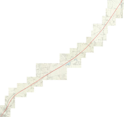
Old Ordnance Survey maps showing the proposed line of the track
Historic Ordnance Survey Maps reproduced with the permission of the National Library of Scotland. Sources
Text & photographs © Ian Mulcahy. Contact photos@iansapps.co.uk or visit my 'Use of my photographs' page for licensing queries (ground level photographs only). |
|
